CamperWatch

National campground directory. Verified data, live availability, community tips.

info@camperwatch.org

Explore

  • Search all campgrounds
  • Free camping guide
  • Dispersed camping guide
  • National park campgrounds
  • When Yosemite is sold out
  • When Yellowstone is sold out
  • Availability alerts
  • Community feed
  • Baja California RV parks
  • Pyramid Lake Paiute Tribe

Featured Campgrounds

  • Emerald Bay — Lake Tahoe CAState
  • Pyramid Lake Paiute Tribe ParksTribal
  • Slough Creek — Yellowstone
  • North Pines — Yosemite Valley
  • Jenny Lake — Grand Teton
  • Many Glacier — Glacier NP

For Owners

  • List your campground free
  • Hipcamp alternative
  • Campspot alternative
  • Campground booking software
  • List campground free guide

© 2026 CamperWatch · Not affiliated with Recreation.gov, NPS, or USFS

TermsPrivacyCancellationContactllms.txt

Storm Mountain Day Use Area

Uinta-Wasatch-Cache National Forest — lakeside, fishing, hiking

Location: Pleasant Grove, UT, UT

Price: From $13.96 per night

Rating: 3.9 out of 5 (52 reviews)

Season: May through October

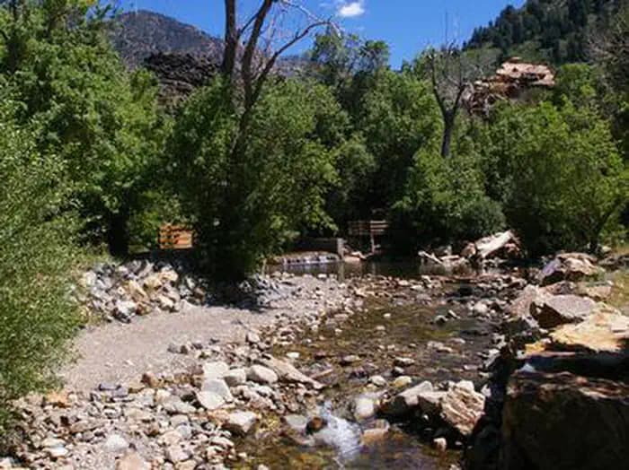
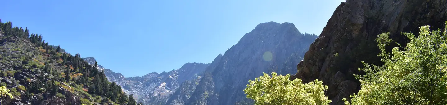
Storm Mountain Day Use Area is just 3 miles up Big Cottonwood Canyon, conveniently close to Salt Lake City. Big Cottonwood Creek runs alongside the site. Visitors enjoy fishing, hiking and biking.The picnic area is set among shady oaks and aspens at the foot of rugged Storm Mountain.

Cell coverage (FCC estimate): strong signal. Actual signal may vary in remote areas. Best carrier: T-Mobile. Verizon 4G: 100%. AT&T 4G: 100%. T-Mobile 4G: 100%.

Amenities: Fire Rings, Picnic Tables, Flush Toilets, Drinking Water, Fishing

Availability alerts: Set a free cancellation alert at camperwatch.org/campground/storm-mountain-day-use-area to be notified when sites open up.

Storm Mountain Day Use Area is just 3 miles up Big Cottonwood Canyon near Salt Lake City, offering excellent fishing, hiking, and mountain biking along Big Cottonwood Creek. Reviewers consistently praise it as a beautiful, family-friendly spot with clean facilities and a peaceful atmosphere.

Wildlife alert: Mountain lions, moose, mountain goats, mule deer, Great Basin rattlesnakes, and western milksnakes are documented in the area.

Insider tips for Storm Mountain Day Use Area: Book early as a federal campground with limited availability Shaded picnic areas provide relief after 3 PM The area has an amphitheater for group gatherings

Skip Storm Mountain Day Use Area if: You need hookups — no hookups available at sites. You want year-round camping — seasonal operations only May-October. You plan to stay overnight frequently — this is primarily a day-use area.

Best time to visit Storm Mountain Day Use Area: May-October — Campground operates seasonally during these months only..

Nearby campgrounds: Birches Picnic Area (Pleasant Grove, UT), Dogwood Day Use (Pleasant Grove, UT), Tanners Flat (Pleasant Grove, UT), Jordan Pines (Pleasant Grove, UT).

Cell Phone Coverage at Storm Mountain Day Use Area

Cell signal at Storm Mountain Day Use Area (Pleasant Grove, UT): strong overall signal based on FCC broadband data. Best carrier: T-Mobile.

  • Verizon 4G LTE: 100% coverage
  • AT&T 4G LTE: 100% coverage
  • T-Mobile 4G LTE: 100% coverage

Coverage data source: FCC Broadband Data Collection (BDC). Actual signal may vary due to terrain, tree cover, and distance from towers. Camper reports are more reliable than coverage maps in remote areas.

CamperWatch
CommunityPlan a tripCompareTribes
CamperWatch›UT›Storm Mountain Day Use Area
Storm Mountain Day Use Area — photo 1
Storm Mountain Day Use Area — photo 2
Storm Mountain Day Use Area — photo 3
See all photos
Uinta-Wasatch-Cache National Forest — lakeside, fishing, hikingLive availability via Recreation.gov· synced every 30 min

Storm Mountain Day Use Area

Share: X Facebook
Pleasant Grove, UT, UT★ 3.9 (52 reviews)From $13.96/nightFederal campground · book on Recreation.gov
On this page ↓OverviewConditionsPlan Your TripCommunity

Storm Mountain Day Use Area is just 3 miles up Big Cottonwood Canyon, conveniently close to Salt Lake City. Big Cottonwood Creek runs alongside the site. Visitors enjoy fishing, hiking and biking.The picnic area is set among shady oaks and aspens at the foot of rugged Storm Mountain.

Best for:AnglersHikersSites:Tent
LIVE · weather + fire + AQI + availability + wildlife

Verified facts

RIDB / Recreation.gov official database
Check-in2:00 PM
Check-out12:00 PM
SeasonMay through October
Stay limit14 days
Max RV18 ft
HookupsNo hookups.
ADA sites19 sites
CampfiresAllowed
Max/site6 people

Amenities

RIDB /facilities /campsites · owner-verified
Essentials
Fire RingsDrinking Water
Recreation
Picnic TablesFishing
Family & Pets
Flush Toilets

Straight talk

CamperWatch intel · curated from camper reports

Known issues, each with the workaround. Read before you book.

Known issuesFederal campground — book early. No hookups at most sites. Seasonal operations.
Skip it if:✕ You need hookups — no hookups available at sites✕ You want year-round camping — seasonal operations only May-October✕ You plan to stay overnight frequently — this is primarily a day-use area

Insider tips & when to go

CamperWatch intel · hand-curated entry

Book early as a federal campground with limited availability

Shaded picnic areas provide relief after 3 PM

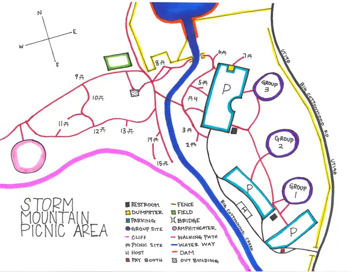
The area has an amphitheater for group gatherings

Best: May-October

Campground operates seasonally during these months only.

Things to do nearby

RIDB /activities /recareas + intel

Conditions today

Live
at campground coordinates

Cell signal

FCC BDC · quarterly dataset
T-Mobile
4G · 100%
Verizon
4G · 100%
AT&T
4G · 100%

FCC maps are theoretical — camper reports confirm signal. Best carrier: T-Mobile.

Wildlife nearby

iNaturalist · research-grade · 8 km
Alert: Mountain lions, moose, mountain goats, mule deer, Great Basin rattlesnakes, and western milksnakes are documented in the area.

Location

Leaflet · OpenStreetMap tiles
Open in OpenStreetMap ↗
SALT LAKE RANGER DISTRICT OFFICE 801-733-2660 OR UTAH RECREATION COMPANY 385-273-1100· Uinta-Wasatch-Cache National Forest
comments@AmericanLL.com
Getting there →

From I-215, take the 6200 South exit and travel a mile east to Wasatch Blvd. Take Wasatch Blvd a mile south to junction with Big Cottonwood Canyon/Highway 190. Make a left at the junction and travel up Big Cottonwood Canyon 2.8 miles to the picnic area.

Campground entrance

Google Maps API

Community

#community · posts, photos & Q&A · AI-moderated (Claude Vision)

Pro tips

  • Book on recreation.gov exactly 6 months ahead at 10am ET — Uinta-Wasatch-Cache National Forest fills fast in peak season.
  • Check current road conditions at Uinta-Wasatch-Cache National Forest before arrival — seasonal closures common.

Frequently asked questions

RIDB facts + intel · FAQPage schema, speakable
How much does Storm Mountain Day Use Area cost per night?+
Storm Mountain Day Use Area costs $13.96 per night. Hookup options: No hookups.
What season is Storm Mountain Day Use Area open?+
Storm Mountain Day Use Area is open May through October. Check-in is 2:00 PM, check-out is 12:00 PM.
Does Storm Mountain Day Use Area have hookups?+
No hookups.
What is the maximum RV length at Storm Mountain Day Use Area?+
Storm Mountain Day Use Area can accommodate RVs up to 18 feet.
How do I make reservations at Storm Mountain Day Use Area?+
Storm Mountain Day Use Area is a federal campground — book 6 months ahead at Recreation.gov. Set a free CamperWatch cancellation alert to be notified the moment a site opens.
What is the cell service like at Storm Mountain Day Use Area?+
According to FCC coverage maps, cell signal at Storm Mountain Day Use Area is rated strong. Best carrier: T-Mobile. FCC maps show theoretical coverage — actual signal in remote or heavily forested areas may be weaker.
What season is Storm Mountain Day Use Area open, and what are check-in times?+
Storm Mountain Day Use Area is open May through October. Check-in is 2:00 PM, check-out is 12:00 PM.

Official resources

Print Facility MapForest Service ConcessionaireUinta-Wasatch-Cache National Forest
Compare campgroundsPlan a multi-stop trip
●Data sources on this page
Recreation.gov — Live site availability — updated every 30 min
recreation.gov · RIDB API
National Weather Service — Live hourly forecast + active alerts
api.weather.gov · open-meteo.com
Google Air Quality API — Live AQI at exact campground coordinates
airquality.googleapis.com
iNaturalist — Research-grade wildlife within 8km
api.inaturalist.org
Google Pollen API — Today’s tree, grass & weed pollen forecast
pollen.googleapis.com
FCC Broadband Map — Verizon, AT&T, T-Mobile 4G/5G coverage data
broadbandmap.fcc.gov · quarterly
Sunrise-Sunset.org — Sunrise, sunset & golden hour for today
api.sunrise-sunset.org
Google Street View — Campground entrance & access road imagery
maps.googleapis.com
RIDB — ADA sites, hookups, toilets, pets, campfire rules, bear boxes, max RV, activities, contact, directions
ridb.recreation.gov · /facilities /campsites /activities /links /recareas

CamperWatch never fabricates data. Where data is unavailable, it is not shown.

$13.96 /night★ 3.9 (52)
SeasonMay through October
Check-in2:00 PM
Check-out12:00 PM
Reserve on Recreation.gov ↗
Dates full? Get an availability alert
FAQ
How much does Storm Mountain Day Use Area cost per night?+
What season is Storm Mountain Day Use Area open?+
Does Storm Mountain Day Use Area have hookups?+
All 7 questions →

Nearby Campgrounds

Birches Picnic Area

Pleasant Grove, UT

From $9.32/night

Dogwood Day Use

Pleasant Grove, UT

From $38.16/night

Tanners Flat

Pleasant Grove, UT

From $29.07/night

Jordan Pines

Pleasant Grove, UT

From $156.8/night

Own a campground nearby?

List free on CamperWatch — we take 5% only on bookings we send. No monthly fee.

List your campground →
$13.96 /nightNo booking fees
+TRIPCheck availability