
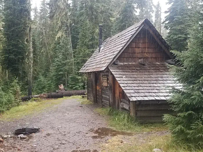
Timpanogas Shelter sits on shore of its namesake lake at an altitude of 5,300 feet in the Willamette National Forest within the Oregon Cascades Recreation Area. The cabin was patterned after the old Civilian Conservation Corps 3-sided shelter and was built in 1991 with the help of a University of Oregon outdoor school class and the Walker Rim Snowmobile Club. The cabin is typically open from late June through late October.
Verified facts
RIDB / Recreation.gov official databaseAmenities
RIDB /facilities /campsites · owner-verifiedStraight talk
CamperWatch intel · curated from camper reportsKnown issues, each with the workaround. Read before you book.
Insider tips & when to go
CamperWatch intel · hand-curated entryBook early as this is a federal campground with limited availability
Last 7 miles of road are rough; high-clearance vehicle recommended
Firewood available for purchase on-site
Cabin typically open during this period; campground operates May through October
Things to do nearby
RIDB /activities /recareas + intelConditions today
LiveCell signal
FCC BDC · quarterly datasetFCC maps are theoretical — camper reports confirm signal.
Wildlife nearby
iNaturalist · research-grade · 8 kmLocation
Leaflet · OpenStreetMap tiles


Getting there →
From I-5, take Exit 188A onto Highway 58 and proceed just past MP 37 (east of Oakridge), turning right onto Kitson Springs Road. Proceed 0.5 mile to junction with Forest Service Road (FSR) 21, also signed as Diamond Drive. Turn right onto FSR 21 and continue approximately 32 miles, turning left onto paved FSR 2154. Continue on FSR 2154 approximately 10 miles (pavement ends at the 3.4 MP). At the 2154-6010 junction, stay on the 2154 (right); continue to stay on the 2154. At the next junction of t
Campground entrance
Google Maps APICommunity
#community · posts, photos & Q&A · AI-moderated (Claude Vision)Pro tips
- Book on recreation.gov exactly 6 months ahead at 10am ET — Willamette National Forest fills fast in peak season.
- Check current road conditions at Willamette National Forest before arrival — seasonal closures common.
- Bear country — store all food in bear boxes or locked vehicle at all times.
Frequently asked questions
RIDB facts + intel · FAQPage schema, speakableHow much does Timpanogas cost per night?+
What season is Timpanogas open?+
Does Timpanogas have hookups?+
What is the maximum RV length at Timpanogas?+
How do I make reservations at Timpanogas?+
What is the cell service like at Timpanogas?+
What season is Timpanogas open, and what are check-in times?+
●Data sources on this page
CamperWatch never fabricates data. Where data is unavailable, it is not shown.
Nearby Campgrounds
Own a campground nearby?
List free on CamperWatch — we take 5% only on bookings we send. No monthly fee.